Indicators of Forest Extent
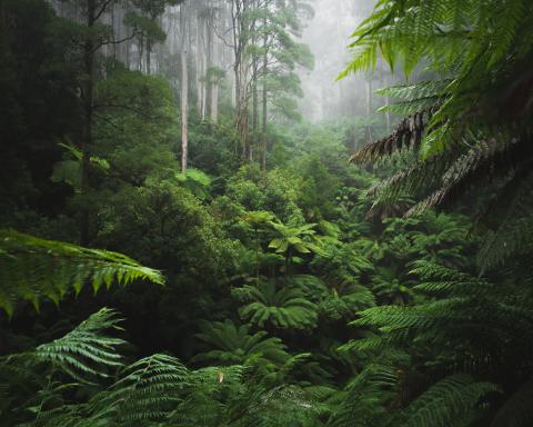
 Primary Forest Loss
Last Updated on April 29, 2026
This indicator aims to monitor the total area of
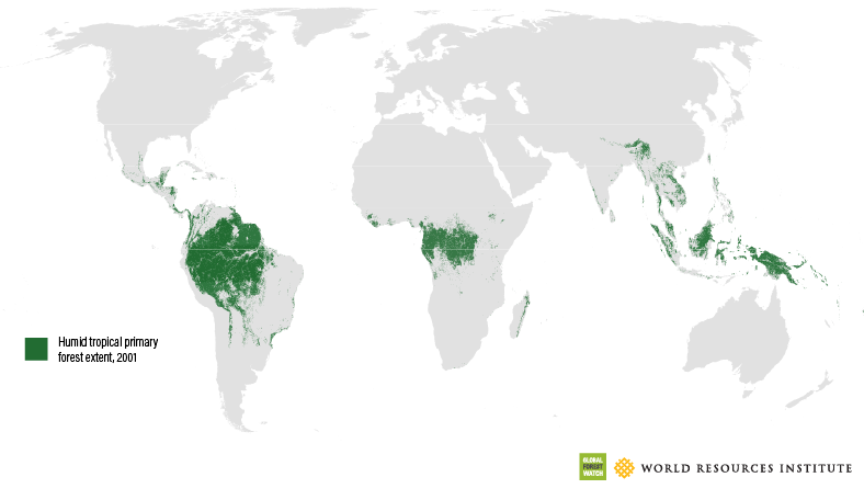
Primary forests have only been mapped comprehensively in the humid tropics. Therefore, this indicator uses maps of
In this section, we'll explore the following questions:
Get the Latest in Your Inbox
Want to stay up to date on the state of the world’s forests? Subscribe to our mailing list.
{"Glossary":{"141":{"name":"agroforestry","description":"A diversified set of agricultural or agropastoral production systems that integrate trees in the agricultural landscape.\r\n"},"101":{"name":"albedo","description":"The ability of surfaces to reflect sunlight.\u0026nbsp;Light-colored surfaces return a large part of the sunrays back to the atmosphere (high albedo). Dark surfaces absorb the rays from the sun (low albedo).\r\n"},"94":{"name":"biodiversity intactness","description":"The proportion and abundance of a location\u0027s original forest community (number of species and individuals) that remain.\u0026nbsp;\r\n"},"95":{"name":"biodiversity significance","description":"The importance of an area for the persistence of forest-dependent species based on range rarity.\r\n"},"142":{"name":"boundary plantings","description":"Trees planted along boundaries or property lines to mark them well.\r\n"},"98":{"name":"carbon dioxide equivalent (CO2e)","description":"Carbon dioxide equivalent (CO2e) is a measure used to aggregate emissions from various greenhouse gases (GHGs) on the basis of their 100-year global warming potentials by equating non-CO2 GHGs to the equivalent amount of CO2.\r\n"},"153":{"name":"climate domain","description":"Major ecosystem regions, summarized as boreal, temperate, tropical and subtropical.\u0026nbsp;"},"99":{"name":"CO2e","description":"Carbon dioxide equivalent (CO2e) is a measure used to aggregate emissions from various greenhouse gases (GHGs) on the basis of their 100-year global warming potentials by equating non-CO2 GHGs to the equivalent amount of CO2.\r\n"},"1":{"name":"deforestation","description":"The change from forest to another land cover or land use, such as forest to plantation or forest to urban area.\r\n"},"77":{"name":"deforested","description":"The change from forest to another land cover or land use, such as forest to plantation or forest to urban area.\r\n"},"76":{"name":"degradation","description":"The reduction in a forest\u2019s ability to perform ecosystem services, such as carbon storage and water regulation, due to natural and anthropogenic changes.\r\n"},"75":{"name":"degraded","description":"The reduction in a forest\u2019s ability to perform ecosystem services, such as carbon storage and water regulation, due to natural and anthropogenic changes.\r\n"},"79":{"name":"disturbances","description":"A discrete event that changes the structure of a forest ecosystem.\r\n"},"68":{"name":"disturbed","description":"A discrete event that changes the structure of a forest ecosystem.\r\n"},"65":{"name":"driver of tree cover loss","description":"The cause of tree cover loss, such as agriculture or urban development. There are direct drivers, which are the immediate cause of the loss, and indirect drivers, which are the secondary cause of loss (i.e., land speculation)."},"70":{"name":"drivers of loss","description":"The cause of tree cover loss, such as agriculture or urban development. There are direct drivers, which are the immediate cause of the loss, and indirect drivers, which are the secondary cause of loss (i.e., land speculation)."},"81":{"name":"drivers of tree cover loss","description":"The cause of tree cover loss, such as agriculture or urban development. There are direct drivers, which are the immediate cause of the loss, and indirect drivers, which are the secondary cause of loss (i.e., land speculation)."},"102":{"name":"evapotranspiration","description":"When solar energy hitting a forest converts liquid water into water vapor (carrying energy as latent heat) through evaporation and transpiration.\r\n"},"154":{"name":"fastwood monoculture","description":"Stands of single species planted trees that grow quickly.\u0026nbsp;"},"53":{"name":"forest degradation","description":"The reduction in a forest\u2019s quality and ability to perform ecosystem services, such as carbon storage and water regulation, due to natural and anthropogenic changes."},"54":{"name":"forest disturbance","description":"A discrete event that changes the structure of a forest ecosystem.\r\n"},"100":{"name":"forest disturbances","description":"A discrete event that changes the structure of a forest ecosystem.\r\n"},"5":{"name":"forest fragmentation","description":"The breaking of large, contiguous forests into smaller pieces, with other land cover types interspersed.\r\n"},"155":{"name":"Forest Landscape Restoration","description":"The ongoing process of restoring landscapes to regain ecological functionality and enhance human well-being across deforested or degraded forest landscapes."},"156":{"name":"forest moratorium","description":"A temporary restriction on activities that cause forest loss or degradation."},"69":{"name":"fragmentation","description":"The breaking of large, contiguous forests into smaller pieces, with other land cover types interspersed.\r\n"},"80":{"name":"fragmented","description":"The breaking of large, contiguous forests into smaller pieces, with other land cover types interspersed.\r\n"},"74":{"name":"gain","description":"The establishment of tree canopy in an area that previously had no tree cover. Tree cover gain may indicate a number of potential activities, including natural forest growth or the crop rotation cycle of tree plantations.\r\n"},"143":{"name":"global land squeeze","description":"Pressure on finite land resources to produce food, feed and fuel for a growing human population while also sustaining biodiversity and providing ecosystem services.\r\n"},"7":{"name":"hectare","description":"One hectare equals 100 square meters, 2.47 acres, or 0.01 square kilometers.\r\n"},"66":{"name":"hectares","description":"One hectare equals 100 square meters, 2.47 acres, or 0.01 square kilometers."},"67":{"name":"intact","description":"A forest that contains no signs of human activity or habitat fragmentation as determined by remote sensing images and is large enough to maintain all native biological biodiversity.\r\n"},"78":{"name":"intact forest","description":"A forest that contains no signs of human activity or habitat fragmentation as determined by remote sensing images and is large enough to maintain all native biological biodiversity.\r\n"},"8":{"name":"intact forests","description":"A forest that contains no signs of human activity or habitat fragmentation as determined by remote sensing images and is large enough to maintain all native biological biodiversity.\r\n"},"55":{"name":"land and environmental defenders","description":"People who peacefully promote and protect rights related to land and\/or the environment.\r\n"},"161":{"name":"logging concession","description":"A legal agreement allowing an entity the right to manage a public forest for production purposes, including for timber and other wood products."},"157":{"name":"logging concessions","description":"A legal agreement allowing an entity the right to manage a public forest for production purposes, including for timber and other wood products."},"160":{"name":"Logging concessions","description":"A legal agreement allowing an entity the right to manage a public forest for production purposes, including for timber and other wood products."},"9":{"name":"loss driver","description":"The cause of tree cover loss, such as agriculture or urban development. There are direct drivers, which are the immediate cause of the loss, and indirect drivers, which are the secondary cause of loss (i.e., land speculation).\r\n"},"10":{"name":"low tree canopy density","description":"Less than 30 percent tree canopy density.\r\n"},"104":{"name":"managed natural forests","description":"Naturally regenerated forests with signs of management, including logging and clear cuts.Lesiv et al. 2022, https:\/\/doi.org\/10.1038\/s41597-022-01332-3"},"91":{"name":"megacities","description":"A city with more than 10 million people.\r\n"},"57":{"name":"megacity","description":"A city with more than 10 million people."},"86":{"name":"natural","description":"A forest that that grows with limited or no human intervention. Natural forests can be managed or unmanaged (see separate definitions).\u0026nbsp;"},"12":{"name":"natural forest","description":"A forest that that grows with limited or no human intervention. Natural forests can be managed or unmanaged (see separate definitions). \r\n"},"63":{"name":"natural forests","description":"A forest that that grows with limited or no human intervention. Natural forests can be managed or unmanaged (see separate definitions).\u0026nbsp;"},"144":{"name":"open canopy systems","description":"Individual tree crowns that do not overlap to form a continuous canopy layer.\r\n"},"88":{"name":"planted","description":"Stands of trees established through planting, including both planted forest and tree crops."},"14":{"name":"planted forest","description":"Planted trees \u2014 other than tree crops \u2014 grown for wood and wood fiber production or for ecosystem protection against wind and\/or soil erosion.\r\n"},"73":{"name":"planted forests","description":"Planted trees \u2014 other than tree crops \u2014 grown for wood and wood fiber production or for ecosystem protection against wind and\/or soil erosion."},"148":{"name":"planted trees","description":"Stands of trees established through planting, including both planted forest and tree crops."},"149":{"name":"Planted trees","description":"Stands of trees established through planting, including both planted forest and tree crops."},"15":{"name":"primary forest","description":"Old-growth forests that are typically high in carbon stock and rich in biodiversity. The GFR uses a humid tropical primary rainforest data set, representing forests in the humid tropics that have not been cleared in recent years.\r\n"},"64":{"name":"primary forests","description":"Old-growth forests that are typically high in carbon stock and rich in biodiversity. The GFR uses a humid tropical primary rainforest data set, representing forests in the humid tropics that have not been cleared in recent years.\r\n"},"58":{"name":"production forest","description":"A forest where the primary management objective is to produce timber, pulp, fuelwood, and\/or nonwood forest products."},"89":{"name":"production forests","description":"A forest where the primary management objective is to produce timber, pulp, fuelwood, and\/or nonwood forest products.\r\n"},"159":{"name":"restoration","description":"Interventions that aim to improve ecological functionality and enhance human well-being in degraded landscapes. Landscapes may be forested or non-forested."},"87":{"name":"seminatural","description":"Forest with predominantly native trees that have not been planted. Trees are established through silvicultural practices, including natural regeneration or selective thinning.FAO"},"59":{"name":"seminatural forests","description":"Forest with predominantly native trees that have not been planted. Trees are established through silvicultural practices, including natural regeneration or selective thinning.FAO"},"96":{"name":"shifting agriculture","description":"Agricultural practices where forests are cleared, used for agricultural production for a few years, and then temporarily abandoned to allow trees to regrow and soil to recover.\u0026nbsp;"},"103":{"name":"surface roughness","description":"Surface roughness of forests creates\u0026nbsp;turbulence that slows near-surface winds and cools the land as it lifts heat from low-albedo leaves and moisture from evapotranspiration high into the atmosphere and slows otherwise-drying winds. \r\n"},"17":{"name":"tree cover","description":"All vegetation greater than five meters in height and may take the form of natural forests or plantations across a range of canopy densities. Unless otherwise specified, the GFR uses greater than 30 percent tree canopy density for calculations.\r\n"},"71":{"name":"tree cover canopy density is low","description":"The percent of ground area covered by the leafy tops of trees. tree cover: All vegetation greater than five meters in height and may take the form of natural forests or plantations across a range of canopy densities. Unless otherwise specified, the GFR uses greater than 30 percent tree canopy density for calculations.\u0026nbsp;\u0026nbsp;"},"60":{"name":"tree cover gain","description":"The establishment of tree canopy in an area that previously had no tree cover. Tree cover gain may indicate a number of potential activities, including natural forest growth or the crop rotation cycle of tree plantations.\u0026nbsp;As such, tree cover gain does not equate to restoration.\r\n"},"18":{"name":"tree cover loss","description":"The removal or mortality of tree cover, which can be due to a variety of factors, including mechanical harvesting, fire, disease, or storm damage. As such, loss does not equate to deforestation.\r\n"},"163":{"name":"tree cover loss due to fire","description":"The mortality of tree cover where forest fires were the direct cause of loss.\u0026nbsp;"},"164":{"name":"tree cover loss due to fires","description":"The mortality of tree cover where forest fires were the direct cause of loss.\u0026nbsp;"},"162":{"name":"tree cover loss from fires","description":"The mortality of tree cover where forest fires were the direct cause of loss.\u0026nbsp;"},"150":{"name":"tree crops","description":"Stand of perennial trees that produce agricultural products, such as rubber, oil palm, coffee, coconut, cocoa and orchards."},"85":{"name":"trees outside forests","description":"Trees found in urban areas, alongside roads, or within agricultural land\u0026nbsp;are often referred to as Trees Outside Forests (TOF).\u202f\r\n"},"151":{"name":"unmanaged","description":"A forest that grows without human intervention and has no signs of management, including primary forest.Lesiv et al. 2022, https:\/\/doi.org\/10.1038\/s41597-022-01332-3"},"105":{"name":"unmanaged natural forests","description":"A forest that grows without human intervention and has no signs of management, including primary forest.Lesiv et al. 2022, https:\/\/doi.org\/10.1038\/s41597-022-01332-3"},"158":{"name":"tree cover loss from fire","description":"The mortality of tree cover where forest fires were the direct cause of loss.\u0026nbsp;"}}}
Citation
“Primary Forest Loss Indicator.” Global Forest Review, updated April 29, 2026. Washington, DC: World Resources Institute. Available online at https://research.wri.org/gfr/forest-extent-indicators/primary-forest-loss.